*
First distribution of checks from the My People Fund
News Source:
www.local8now.com/content/news…Posted: Fri 6:30 PM, Dec 09, 2016
Updated: Thu 3:59 PM, Dec 15, 2016
GATLINBURG, Tenn. (WVLT) - The Dollywood Foundation My People Fund announced the dates and locations of the first distribution of checks for those who lost their primary residences in the Sevier County wildfires.
DATES/LOCATION:
Thursday, Dec. 15 Last name A – F
Friday, Dec. 16 Last name G – L
Monday, Dec. 19 Last name M – R
Tuesday, Dec. 20 Last name S – Z
10 a.m. – 7 p.m. each day at the CARE MORE Assistance Center inside the LeConte Event Center
2986 Teaster Ln., Pigeon Forge, TN 37863
Applicants were asked to park and check-in adjacent to the LeConte Center in a municipal parking lot.
Eligible families registered to receive $1,000 a month for six months by visiting dollywoodfoundation.org. A release by the Dollywood Foundation said county officials are using the U.S. Geological Survey of damage in the area and cross-referencing with official documents to ensure that families who lost their primary residences receive funds.
As of Friday, more than 900 people had applied for funds, with more expected to apply on line. A release from the Dollywood Foundation urged only heads of households to report on the day that correlates with their last name. Those reporting should be prepared to present photo identification.
The first distribution was scheduled to precede six other distributions.

Dolly Parton, Smoky Mountains Rise
Smoky Mountains Rise Raises Nine Million Dollars News Source:
www.local8now.com/content/news…Posted: Fri 8:52 AM, Dec 09, 2016
Updated: Wed 9:45 PM, Dec 14, 2016
KNOXVILLE, Tenn. (WVLT) -- Smoky Mountains Rise: A Benefit for the My People Fund aired on MyVLT on December 13 and raised $9 million. A statement released by the Dollywood Foundation said the total amount raised is expected to rise as mail donations are counted and the telethon is rebroadcast to new audiences over the next five days.
The three hour long benefit concert featured countless celebrity appearances and check presentations. Generous contributions were made by Kenny Chesney, Chris Young, Paul Simon, Taylor Swift, Dierks Bentley, Kid Rock, Dollar General, CMT, Blalock Construction, Belmont University, Tennessee Titans, WIVK, Local 8 News and many more.
Alison Krauss, Reba McEntire, Cyndi Lauper, Lauren Alaina, Alabama, Dolly Parton, Kenny Rogers, Amy Grant, LOCASH, Big & Rich, Chris Stapleton, Hank Williams Junior, Aaron Lewis, Rhonda Vincent and so many others performed during the three hour long telethon organized by Dolly Parton to support those affected by the recent wildfires in and around Gatlinburg, Tennessee.
Parton announced the My People Fund on Nov. 30, after the airing of Christmas of Many Colors: Circle of Love, and has already pledged to provide $1000 each month to Sevier County families whose homes are uninhabitable or were completely destroyed in the recent Smoky Mountain wildfires.
Viewers were asked to call 1-866-CARE MORE to donate to the My People Fund. The lines were so busy that another phone line was added. When the telethon ended at 11 p.m. Dolly Parton tweeted that the concert would air again on West Coast time to allow for more donations. She also stated that donations to
#MyPeopleFund will make a world of difference for so many who have lost everything in the TN wildfires.
Anyone who would like to make a tax-deductible contribution to the My People Fund may visit
dollywoodfoundation.org. For those wishing to send donations via mail, those contributions should be sent to: My People Fund, c/o Dollywood Foundation, 111 Dollywood Lane, Pigeon Forge, TN 37863.
LATEST UPDATES: 14 dead, 191 injured in Sevier Co. wildfires
Posted: Mon 5:03 PM, Nov 28, 2016
Updated: Tue 12:32 PM, Dec 13, 2016
News Source:
www.local8now.com/content/news…SEVIER COUNTY, Tenn. (WVLT) -- Officials confirmed that 14 people are dead and 191 people were injured in the heartbreaking Sevier County wildfires.
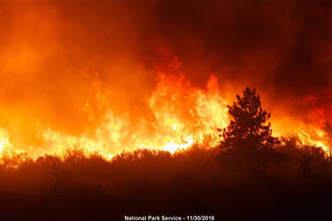
In all, 2,460 structures have been damaged or destroyed. 1,123 residential structures were destroyed in the county, 981 in Gatlinburg, and 17 in Pigeon Forge. 53 commercial structures were destroyed in Gatlinburg, 5 in the county, and zero in Pigeon Forge. 7 residential structures in the county have major damage, 7 in Gatlinburg, and none in Pigeon Forge. 3 commercial structures in Gatlinburg have major damage. 42 residential structures in the county have minor damage and 29 in Gatlinburg. 1 commercial structure in the county and 1 in Gatlinburg have minor damage. 126 residential structures in the county were affected by the fires, 54 in Gatlinburg, and 1 in Pigeon Forge. 9 commercial structures in Gatlinburg and 1 in the county were affected. At a press conference on Tuesday, Mayor Waters told media outlets that the fires caused more than an estimated $500 million in damages.
As of Tuesday, 6 hand crews, 15 engines, 1 helicopter, 209 total personnel were fighting the Chimney Top 2 Fire as a part of the Type 1 Federal Incident Management Team. The Chimney Top 2 Fire was estimated to be 94% contained with 17,140 acres, and the Cobbly Nob Fire was estimated to be 96% contained with 764 acres. Mayor Waters said all fires have been extinguished.
Authorities told media outlets Wednesday that two juveniles have been charged with aggravated arson for allegedly starting the Sevier Co. wildfires. The juveniles are not from Sevier County, but are from Tennessee. The investigation is ongoing.
The Water Boil Advisory is still in effect for the following areas in Gatlinburg: Greystone Heights, Smoky View Road and Campbell Lead, Cliff Branch Road (inside the city) and the portion of Wiley Oakley Drive between Ski View Drive and Compbell Lead Road. The Water Boil Advisory was lifted for the downtown area.
As of Friday, water had been re-established and the following areas were added to the boil water advisory: Kings Way, Colt Lane, Loop Road, Topside Road and Drive, Little Fox Road, Forest Springs Drive, Foothills Drive, Stone Fence Lane, Spring Drive, Silverbell Heights, the 300 block of Silverbell Lane, Chimney Tops Way, Abrams Falls Way and Parsons Branch Way.
City leaders identified some of the people who died as a result of the wildfires.
Elaine Brown, 81, died after she sustained a medical event that caused a multi-vehicle accidents on Wears Valley Road while fleeing the fire.
Edward Taylor, 85, unknown address; Bradley Phillips, age 59, discovered at 412 Long Hollow Road; and Constance Reed, age 34, Chloe Reed, age 12, and Lily Reed, age 9, discovered at 347 Wiley Oakley Drive.
John Tegler, 71, and Marilyn Tegler, 70, were dual citizens from Woodstock, Ontario, but owned a vacation home on North Skyline Drive in Chalet Village. Their son, Scott, was notified at 6 p.m. on December 1. Their son-in-law, Dave Lapointe told CBC News that the couple had been living in the U.S. for about 20 years.
Jon Summers, 61, and Janet Summers, 61, were from Memphis, Tennessee. They were staying in Chalet Village on Crooked Ridge Road. Their three sons Paul, Shawn, and Phillip were sent to the burn unit at Vanderbilt Medical Center. One of the brothers was released from the hospital while the other two are still being treated for burns. Jon's brother, Jim, was notified at 5:40 p.m. on December 1.
Officials said May Vance died of a heart attack in the wildfires and did not release further information. Vance is from Gatlinburg.
Officials identified Robert A. Hejny, 63, who was found at Traveler's Motel in Gatlinburg.
The family of Alice Hagler confirmed to Local 8 News Thursday morning that she passed away. Officials confirmed her death on Friday afternoon. Hagler was reported missing Tuesday; she was last seen at her home on Piney Butt Loop in Gatlinburg.
Officials said three people were found dead from fires in the Chalet Village area, and one person was discovered dead near a motel on Highway 321. Three more people were found dead on Campbell Lead Road. Authorities did not release details about the other fatalities.
Two others were rescued safely at Westgate Resorts and one person was rescued on Ski Mountain.
The Tennessee Bureau of Investigation said it received over 100 phone calls, since it established a hotline, 1-800-TBI-FIND, for people to call with reports of missing loved ones. Agents closed more than 150 leads on missing persons.
On Wednesday, December 7, property owners, business owners, renters, and lease holders were allowed to return to full-time occupancy beginning at 7:00 a.m. through the East Parkway (Hwy. 321) entry point. 13 people are staying at the Red Cross shelter.
Officials said there is a temporary landfill site for damaged property next to the current landfill on Ridge Road.
The City of Gatlinburg reopened for business and to the general public on Friday, December 9 at 7 a.m. Major roadways were opened, but some city roadways remained closed for utility work.
Great Smoky Mountains National Park officially reopened to the public on Friday, December 9 in conjunction with the reopening of the city of Gatlinburg. Newfound Gap Road, Little River Road, and several visitor areas have opened which were closed since the evening of Monday, November 28 due to the Chimney Tops 2 wildfire. The Spur between Pigeon Forge and Gatlinburg is open from Pigeon Forge to the Gatlinburg Welcome Center. Wiley Oakley and Cliff Branch Roads are now open.
The following trails are closed due to wind or fire damage: Chimney Tops Trail, Road Prong Trail, Sugarland Mountain Trail from Mt Collins Shelter to Little River Road, Huskey Gap Trail, Rough Creek Trail, Old Sugarlands Trail, Twin Creeks Trail, Baskins Creek Trail, Bull Head Trail, Rainbow Falls Trail, Trillium Gap Trail, Grapeyard Ridge Trail from Campsite 32 to Roaring Fork Motor Nature Trail, Gatlinburg Trail, Cove Mountain Trail, Sugarland Valley Nature Trail, Noah Bud Ogle Nature Trail, Cove Hardwood Nature Trail, the Sugarlands Horse Concession trails, and the quiet walkways along Newfound Gap Road.
All park campsites that are normally open this time of year are open, with the exception of Campsite 21 on Huskey Gap Trail.
Cherokee Orchard Road in Great Smoky Mountains National Park remains closed.
Several upcoming park events were postponed or cancelled. The Festival of Christmas Past, scheduled for December 10, was cancelled. The Hike 100 Centennial Challenge celebration, scheduled for December 9 at the Gatlinburg Convention Center, was postponed. The Holiday Homecoming at the Oconaluftee Mountain Farm will take place as planned on December 17.
A mandatory evacuation order was issued on November 28 for downtown Gatlinburg residents and guests after TEMA issued a Level 3 State of Emergency with 70 homes in Wears Valley, 70 homes in Cobbly Nob, and 150 structures damaged or destroyed by fire in Sevier County, including a 16-story hotel on Regan Drive, and the Driftwood Apartments near the Park Vista Hotel. The mandatory emergency evacuation for Pigeon Forge was lifted Tuesday. The National Guard was mobilized to Sevier County.
TEMA reports that 14,000 people evacuated Sevier County on November 28. Officials say mass evacuation notifications went out on cell phones at 9:04 p.m. on November 28.
All Sevier County Schools have reopened with the exception of Pi Beta Phi Elementary School. Officials announced that Pi Beta Phi Elementary had minor damage and smoke damage.
Officials with the Great Smoky Mountains National Park issued an air quality advisory and closed the park on November 28. According to an update from GSMNP on November 29, park officials reported "widespread fire damage" and continued fire activity throughout the Gatlinburg area and much of Sevier County including Wears Valley, Pigeon Forge and Jones Cove.
Investigators say the Chimney 2 fire started on November 23 on the north spire of the Chimney Tops. The incident commander returned the next morning and determined that a fire line was not needed. Investigators saw small growth Saturday. Winds picked up and additional firefighters and helicopters were ordered Sunday. The GSMNP Deputy Superintendent said the fire did not pose a threat to the public before the wind picked up. Spot fires spread outside the containment area on November 27. At 11:35 a.m. Monday, officials noticed a spot fire near Twin Creek that crossed drainages. The fire spread to the North as the Gatlinburg Fire Department prepared to battle the South end of the city. The Gatlinburg fire chief told media outlets the fire projections showed there would be no spread to Gatlinburg until midday Tuesday.
Officials say door to door evacuations started in Mynatt Park on Monday afternoon. At 6:27 p.m. other mandatory evacuations were made in the area. Ski Mountain was added to the mandatory evacuations list at 8 p.m. Monday. The Gatlinburg Fire Chief said TEMA did not send out a mass evacuation alert because the verbiage was not correct and cell phone towers crashed, making it difficult to communicate. A siren alarm system was used to evacuate the Gatlinburg area.
Mayor Waters said the state law needs to be changed to allow county mayors to order mandatory evacuations.
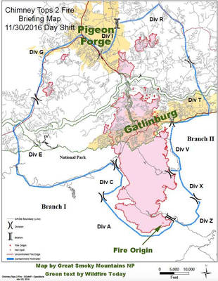
 Timeline: Gatlinburg wildfires
 National Park Service explains how Chimney Tops 2 fire spread to Gatlinburg
News Source:
wate.com/2016/12/13/timeline-g…WATE 6 staff
Published: December 13, 2016, 2:29 pm
Updated: December 13, 2016, 3:31 pm
GATLINBURG (WATE) – The National Park Service is continuing to fight the Chimney Tops 2 fire, but at a news conference Tuesday the Great Smoky Mountain Association and the Gatlinburg Fire Department outlined some of the decisions they made. They outline how the fire grew from a little more than an acre to over 1,700 acres.
At 5:30 p.m. park firefighters observed a smoke column at the top of the Chimney Tops, which is located about 5.5 miles from the city of Gatlinburg. Clay Jordan, Deputy Superintendent of the Great Smoky Mountains National Park, said the fire was about 1.5 acres in size, located in the North Spire.
“As darkness approached, a firefighting team hiked up the mountain to size-up the fire. They discovered the fire burning among a rock scramble at the top,” said Jordan. “Accessing this area of Chimney Tops is about a quarter mile rock scramble, beyond the peak that most hikers climb to at the end of the Chimney Tops trail.
Jordan said the park’s fire management officer was designated the incident commander. He said the fire management officer had 25 years of training and experience fighting wildland fires in the northeast with both the U.S. Forest Service and the National Park Service. With the rocky terrain and darkness, he said firefighters returned because there was nothing further they could do that evening.
Wednesday, November 23 - 1.5 acres
The next morning, Jordan said the incident commander returned to the fire with a squad of firefighters. He said at that point the fire was creeping and smoldering in the thick vegetation at the top of the rocky summit.
“Given the inaccessible terrain, comprised of cliffs and thick vegetation, the crew decided that it was not safe, nor effective to dig a fire line around it, close to the fire, which is generally done by removing that vegetation down to bare soil as a method to stop the fire,” said Jordan. “They also knew that using helicopters to drop water on the fire would be ineffective. Bucket drops are used to slow an intensely burning fire, but they do not put out even a small wildland fire that is burning in deep duff.
Thursday, November 24
The park’s fire management team applied an indirect attack strategy by identifying a 410-acre containment area where the terrain allowed the fire to be fought safely and effectively, according to Jordan. He said that is a standard firefighter suppression strategy in mountainous terrain.
Jordan said he was briefed on the plan of attack along with the park’s chief ranger and they all agreed that the fire attack plan was the only practical option for controlling the fire as quickly as possible.
Friday, November 25
The fire continued to back down the steep rocky slopes.
Firefighters continued to scout for routes to construct firelines closer to the fire, but no effective alternatives were found, according to Jordan.
Saturday, November 26 - 6 acres
By Saturday the fire had grown to six acres. A 4-Day Near Term Analysis from the USFS Rocky Mountain Research Station was requested. Jordan said their analysis modelled slow fire growth downhill over the next couple of days as the fire approached the containment boundaries.
The forecast did not model the behavior the fire generated on Monday, according to Jordan.
Sunday, November 27 - 35 acres
On Sunday, the WATE 6 Storm Team says winds picked-up and the humidity dropped. Jordan said the changing conditions allowed the fire activity to pick-up. The WATE 6 Storm Team and the National Weather Service issued a high wind watch predicting strong winds developing late Monday afternoon.
Jodan said Great Smoky Mountain National Park requested a spot weather forecast for the fire from the National Weather Service. He said the forecast predicted winds of 12 miles per hour gusting to 25 miles per hour in the morning to increase to 20 miles per hour and gusts to 40 miles per hour by 6 p.m. He said the prediction was much lower than the winds actually experienced throughout the day and evening on Monday, considering gusts recorded nearby were up to 87 miles per hour.
In anticipation of the high-wind forecast, Jordan said they ordered three large helicopters, in an effort to slow the intensity of the fire as it continued to back down steep slopes toward the containment lines. Helicopters dumped water on the hottest sections throughout the afternoon.
Meanwhile, Jordan said ground personnel worked on constructing firelines and improving the natural boundaries of the containment area. An order was placed for additional firefighters and wildland fire engines in preparation for the next day.
Late in the day Sunday, the fire was still at around 35 acres as mapped from the air using infrared sensors.
Monday, November 28
Overnight, the WATE 6 Storm Team says the weather changed overnight. Strong winds pushed the fire towards the northeast.
After the sun rose, Jordan said park staff discovered that burning embers had created smaller fires called “spot fires” as far as a half a mile to 1 mile from the main fire burning on Chimney Tops. Those fires were around Chimneys Picnic Area. There was also a spot fire on Bullhead Ridge.
“What we were observing was extraordinary fire behavior,” said Jordan. “Spot fires half a mile or more from the fire in this part of the country, in our experience, are extremely rare. In fact, the incident commander had never experienced this in the Southeast in his 25 years of fighting wildland fire.”Given the strong winds, exceptionally dry conditions and fire on the ridgelines out of reach of firefighters, containment of the fire was going to require a much larger effort once the winds died down.”
Jordan said they immediately ordered the response of a large number of firefighting crews, air resources and a complex fire incident management team. At that point, he said the spot fire on Bullhead Ridge was still 4.5 miles away from Gatlinburg and separated by several mountain drainages.
“It seemed inconceivable that this fire should pose any kind of threat to the community before the weather was expected to calm that night. But given the extreme behavior we had observed, we notified Gatlinburg Fire Department of the situation anyway so they could watch for spot fires, as unlikely as it seemed at the time,” said Jordan.
With additional resources arriving, Jordan said the park’s focus shifted to what they could do to protect threatened park structures using wildland fire engines.
“We were unable to track the movement of the fire very well over the next few hours with the whole region shrouded in smoke. Plus, aircraft were unable to fly in the strong winds,” said Jordan. “Hidden from our view, yet another extraordinary aspect of this fire was occurring.”
At around 11:35 a.m., Jordan said a spot fire was discovered in the Twin Creeks are of the park, about 1.5 miles up Cherokee Orchard Road from the Gatlinburg city boundary. The fire was about three miles downwind from the Bullhead Ridge spot fire.
“We don’t know just how the fire crossed the drainages between the two locations: whether embers hopped from ridge top to ridge top, each time starting a new fire that would then grow hot enough to shoot off new embers, or whether some ember managed to sail several miles through the air. But either way, it is remarkable that the fire could spread 3 miles in just four and a half hours. This phenomena is usually only seen in the West,” said Jordan.
The Gatlinburg Fire Department and park crews responded to provide structural protection, according to Jordan. He said the park also requested the response of bulldozers from the Tennessee Division of Forestry, dispatched to the park boundary in Gatlinburg.
Over the course of the day, Jordan said the fire spread to the north. He said the Gatlinburg Fire Department prepared to defend the South end of the city from the fire. Just before weather monitoring equipment died due to a power outage, the WATE 6 Storm Team said winds were recorded up to 87 miles per hour at 6:00 p.m. at Cove Mountain, which is just above Gatlinburg.
“First, we believe there was no way we could have controlled the fire prior to the wind event,” said Jordan. “Second, the reality is that we believe no number of firefighters or fire engines could have stopped the spread of such an extreme wind-driven fire.”
The national park said they will continue to explore the lessons learned during the incident and they appreciate the outpouring of support and resources from across the nation in helping to fight the fire.